


This is a guest post by Matthew Medler, a regional coordinator for northern NY, explaining his process for identifying good places to atlas based on studying maps. Matt has also written a series of block profiles.
I love maps almost as much as I love birds, so one of my favorite parts of atlasing is studying maps of a new area before I visit it for the first time. By walking through my Atlas preparations and thought process, I’m hoping that I’ll share some tips that will make your next Atlas visit as productive as possible.
Before I get into the details of exploring an atlas block on a computer, I’d like to emphasize two important points: I never trespass onto private property in search of birds, no matter how good the habitat might look from a map or on the ground; and my safety always takes priority, so I avoid birding from busy roads or parking my car on hills or sharp turns where I might create a dangerous situation.
OK, now for the fun part–exploring maps and coming up with a game plan for an atlas block! I’ve selected the Westport NW priority block, which is located in the Champlain Valley in Essex County. This is an area that I’m generally familiar with, but I’ve done very little breeding season birding within the block boundaries. Here are the links to the satellite and topo maps for the block.
As I start to assess an atlas block, here are the questions I try to answer:
- Are there large patches of forest?
- Is there enough open habitat to support grassland birds?
- Is there water in the block? If so, what types: lake, pond, river, and/or stream?
- Is there a significant change of elevation within the block?
Returning to the Westport NW priority block, I can use the downloadable satellite and topo maps together to answer those questions. The satellite map instantly shows that there is a nice mix of woodland and open areas, so I should be able to get both forest and grassland birds in the block. I don’t use the topo map a lot, but it is helpful for highlighting water in a block, as well as providing elevation information. The topo map for the Westport NW block shows a river flowing through much of the block, as well as several streams, and a few small blue patches that look like they might be ponds. The topo map does not show any major elevational changes, so I don’t have to worry about hiking any mountains in this block!
After doing this initial overview with the downloadable maps, I then switch over to Google Maps to explore the area in more detail. I’ve downloaded the Atlas Priority Blocks layer for Google Maps that Atlas coordinator Julie Hart created, so when I zoom in and out in Google Maps, I know definitively whether a road, wetland, or other feature is in the priority block or not.
The satellite and topo maps also display any public lands found in a block, but in this case, unfortunately, there isn’t any public land. This means that I’ll rely on roadside birding to cover different habitats, so my next step is to use Google Maps to try to identify quieter secondary roads that are conducive to safe birding. I generally avoid birding on state routes, like Rt. 22, and instead focus on smaller roads. This marked-up map shows roads that I think might be good for forest birds (magenta) and grassland birds (yellow):
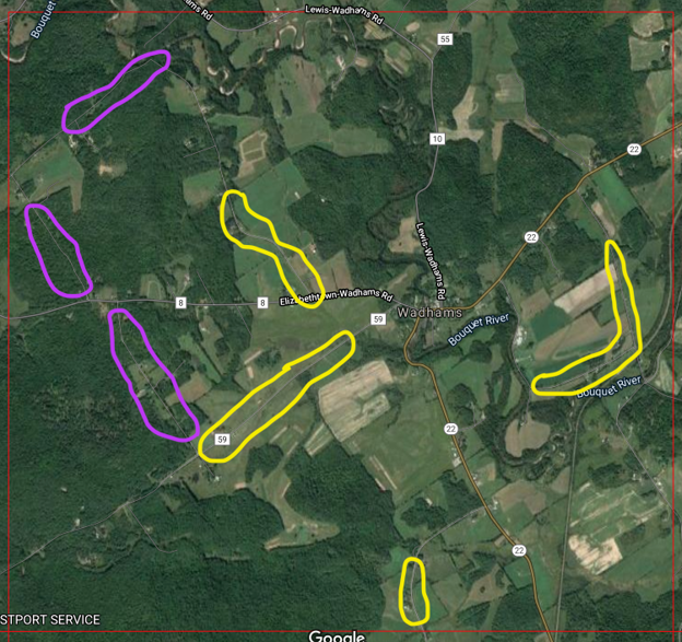
Map of Westport NW priority block with target forested areas in purple and open land in yellow.
Once I’m actually in the atlas block, I can then assess these areas further. If one of the roads is busy, I’ll skip it, and try one of the other spots for that habitat instead. Similarly, some of the open areas might be planted in crops, making them undesirable for atlasing. If so, I’ll move on to the next grassland area, hoping that it is an unmowed pasture that can support species like Savannah Sparrow, Bobolink, and Eastern Meadowlark.
The next piece of scoping that I do with maps is to look at the water situation in more detail. The major water feature in this block is the Boquet River, which meanders through much of the block. This is great, as it will allow me to look for multiple places where a road crosses the river, providing possible vantage points to look for breeding Common Merganser and Spotted Sandpiper. In addition, I’ll zoom in on Google Maps to find areas with riparian forest bordering the river, such as this stretch along the Lewis-Wadhams Road:
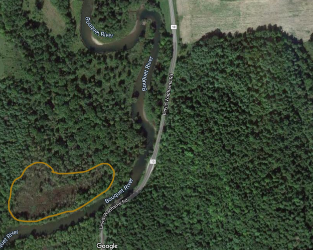
Riparian forest in Westport NW with swampy area circled in brown.
This riparian forest will likely host a different suite of species, such as Warbling Vireo, American Redstart, and Great Crested Flycatcher, than I might find in more upland forest in the block. As a bonus, the brownish patch in the lower left corner (circled in brown) looks like a wooded swampy area that could host something interesting.
The final, most subtle piece of scouting that I’ll do for this block is to try to find small patches of wetlands–either shrub swamps or small cattail marshes–that might support new species for the block, such as Swamp Sparrow, Alder Flycatcher, Marsh Wren, and Virginia Rail. To do this, I return to the topo map and look for flat areas with small streams. In the Westport NW block, I see this type of situation in the southeastern part of the block, so I’ll zoom into this area on Google Maps and see if I can find some wetland features. Once I’m zoomed in, I can see the outline of a stream, surrounded by what looks to be a wet area:
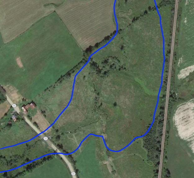
Interesting wetland area in Westport NW.
Notice how the area encircled in blue looks more textured and varied than the surrounding fields–there is some brown mixed in with the green, and you can also see scattered shrubs and a few trees following the contour of the stream. This is definitely an area that I would try to explore further. In this particular example, the Champlain Valley is very fortunate to have a great non-profit organization, the Champlain Area Trail System (CATS), that creates and maintains hiking trails in the area. I believe that there is a CATS trail right in the vicinity of this target wetland, so that might be a good way to access this spot.
After checking the CATS trail map, I learned that there is actually another CATS trail, in forested habitat, elsewhere in the priority block. So that’s a great reminder to be sure to see if there is a local land trust or trail organization that might be active in your area. And that brings up one other map that could be useful as you scout your priority block–be sure to check the eBird hotspot map to see if somebody has already identified hotspots in the area.
I almost forgot one final, valuable habitat to check for atlas purposes: the populated area in the little hamlet of Wadhams. I generally avoid birding in places like this, but in this block, this might be the best spot in the block to pick up “house species” like House Wren, House Finch, House Sparrow, Eastern Phoebe, and Chimney Swift. I would of course be respectful of property owners in this area, avoiding peering into their houses. And under normal (non-pandemic) circumstances, I might even use it as an educational opportunity to talk with people about the atlas. Sometimes these sorts of conversations can even lead to access in other, more interesting parts of a block!
There is no substitute for being out in the field, but I find that this type of advance scouting with maps can be very useful for helping to maximize my field efforts. If you’re new to this type of map study, I encourage you to look at maps and satellite imagery of your block both before and after you’ve visited the block. I hope that this blog post will help you with some of the basics, and then after you’ve visited the block, you can look at your eBird tracks after the fact to make the connection between the habitats in the field and what they look like in the satellite imagery.