
Frontier eBirding - Stikine River 2020

Frontier eBirding – This article is part of a series illuminating eBirding trips to remote parts of Alaska with little ornithological coverage. In the United States, Alaska is unique in its size and remoteness. These combined characteristics have resulted in many parts of the state not receiving much coverage by bird watchers or ornithologists and has created gaps in our understanding of bird communities throughout the state. These articles are designed to document and encourage designated eBirding trips to remote and under-birded parts of the state to fill these knowledge gaps. Much of the state is still left to be discovered and eBirded!
Trip Summary
We birded the roughly 30 km stretch of Stikine River from the Alaska/Canada Border to Twin Lakes Cabin from 27 June – 3 July, 2020. We paddled most adjacent soughs and creeks surrounding the main channel and walked a few marshes looking for some of Alaska’s rarest breeding birds. Highlights from the trip include 1 American Bittern, 4 Red-eyed Vireo, 1 Virginia Rail, 5 Sora, 4 Least Flycatcher, 2 Northern Rough-winged Swallow, 35 Black Swift, 30+ Western Tanager, and 1 Eurasian Collared-Dove.
Previous Knowledge
The Stikine River is the fastest flowing navigable River in North America, and the largest river in Southeast Alaska. The lower section of the river was described by John Muir in 1879 as “A Yosemite a hundred miles long”, a description that holds true today. Starting in northwest British Columbia, the Stikine is a natural corridor leading into the interior, with species assemblages reflecting that. Ornithologically, the river was surveyed as part of a widespread assessment of Southeast Alaska’s Major Mainland Rivers in 2000 and sporadically since.
Pre-trip Logistics
Travel up the Stikine to the border usually starts in Wrangell, AK (although Petersberg, AK could be an alternative departure point). There a few companies that offer water taxi services dropping recreationists off at the border; we used Breakaway Adventures in Wrangell, AK. The only way to travel the river and effectively bird is via canoe (key for gear storage) or kayak. We rented one canoe and one kayak from Alaska Vistas. Alaska Vistas also runs a water taxi up the river, and since Breakaway Adventures appears to be getting out of the water taxi business, Alaska Vistas would be the best bet for future trips. Alaska Vistas was extremely accommodating, helpful, and friendly. After landing in Wrangell, our Breakaway Adventures captain picked us up at the airport and drove us to 56 North (local gear store) to buy camp fuel. He then shuttled us over to Alaska Vistas to pick up our canoe and kayak. After loading our gear and our vessels into the water taxi, we shuttled out to Mt. Flemmer Cabin (~1.5 hours), landing around 18:30. There are a series of USFS cabins along the river that are excellent places to stay, but they must be reserved in advanced at recreation.gov. Bring camping gear as we had our best birding around Barnes Lake, and camping near the lake allowed for ideal early morning access.
The main concern for most birders attempting the trip will be water levels. These levels can be monitored through the USGS gauge along the river. Our water levels were high enough that we could access the sloughs we wanted, but low enough to paddle the main channel safely. The river is fast moving, but there are no rapids along this lower stretch. Consider locations along the main river and large sloughs one-pass, as paddling upstream was very difficult at 20 ft. water levels.
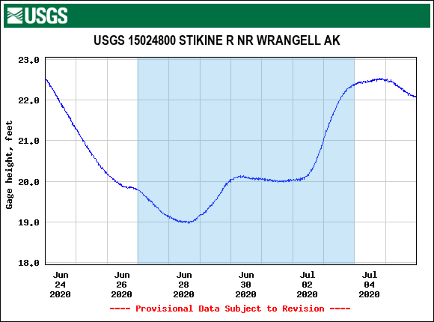
Water levels along the Stikine River in late June and early July, 2020. Days on the river are highlighted in blue.
Trip Account
Day 1: We arrived at Mt. Flemmer Cabin in the evening. We quickly unpacked and headed out for some evening birding before sunset. We used this time to familiarize ourselves with the canoe and kayak and check the feasibility of paddling upstream. Water levels were around 20 ft. for our entire trip, which was adequate to fill sloughs and creeks, though a bit lower might have made paddling up stream easier.
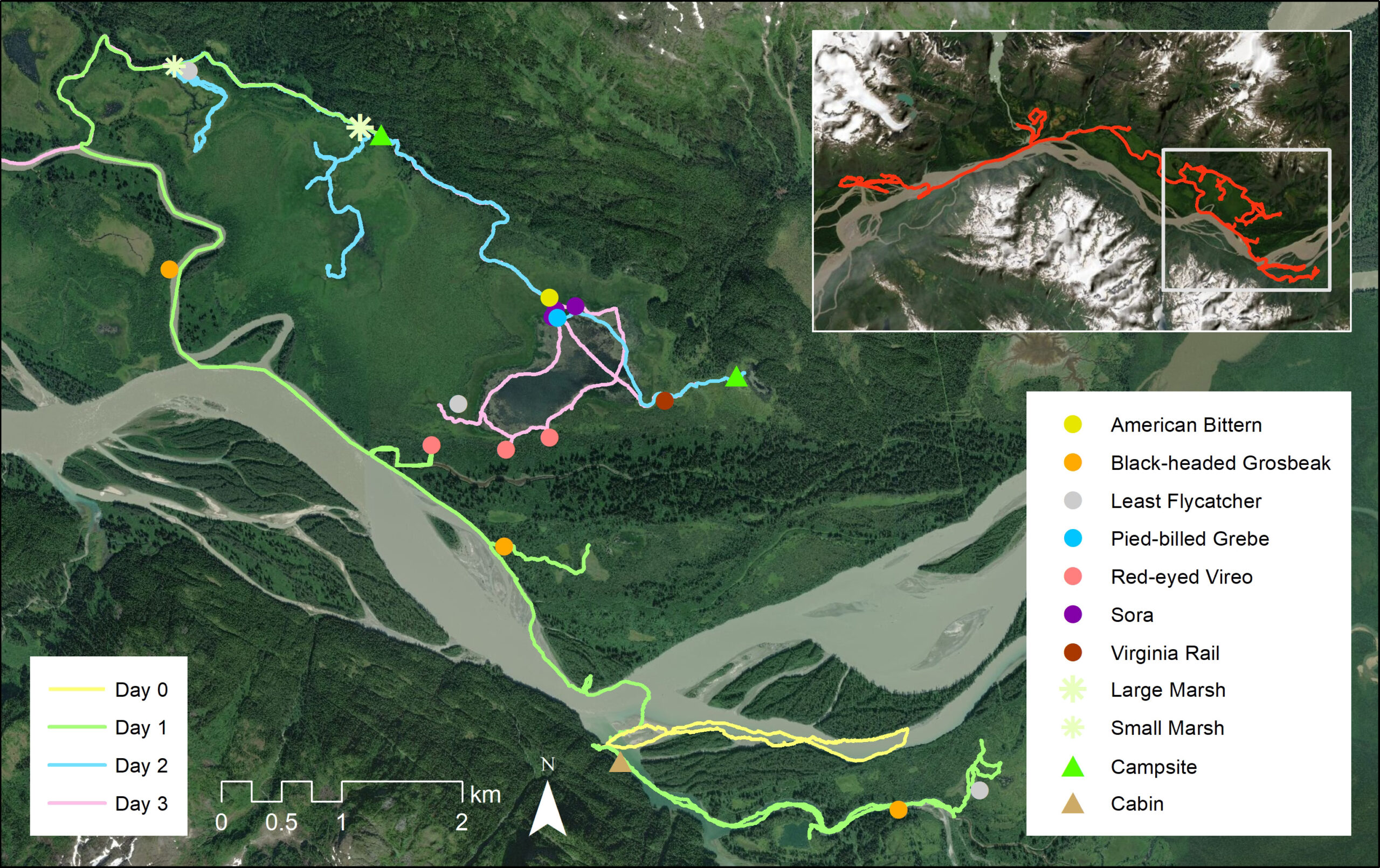
Tracks and locations of birds during the first three days along the Stikine River. Click to enlarge.
Day 2: We paddled up the Kikahe River with ease until Red Slough, where we diverted north toward the two wetlands adjacent to the Alaska/Canada boundary. Along this stretch of river, we had our first Black-headed Grosbeak at 56.63962, -131.86162. Once we arrived at the first marsh, we got out and hiked the perimeter of the wetland and had two Least Flycatchers singing at 56.64080, -131.85050. We explored further toward the border, but we did not detect any other noteworthy species. We paddled back to Mt. Flemmer Cabin to gather our gear and cross the Stikine River and travel along its north side. There are no rapids, but the water moves very quickly and care should be taken when crossing this section. Once across, we skirted the northern bank and popped into a slough at 56.660866, -131.915199 where we paddled upstream crossing four beaver dams and two marshes. We had a moose cow and calf being followed by a brown bear at the first marsh and another adult Black-headed Grosbeak at 56.66057, -131.91331. Continuing along the north side of the river, we dipped into Guerin Slough, where we had our first Red-eyed Vireo at 56.66839, -131.92255.
We beached our vessels and hiked north from Guerin Slough to track down the bird. The devil’s club and alder in this area were quite thick but not entirely impenetrable. From Guerin Slough we headed down the Stikine and turned north into Ketili Slough. We heard an unfamiliar call along the first stretch of Ketili Slough, and upon investigation found a begging Black-headed Grosbeak fledgling which is the first record of Black-headed Grosbeak breeding in Alaska. We continued along this slough until hitting Ketili Creek where we turned north and paddled up the creek until sunset. Camping options were not ideal (thick and uneven), but camping along the creek allowed us easier access to the two marshes we planned to check the next morning. This section of the Ketili Creek had impressive numbers of Western Tanagers (7+). This was our longest day (both hours and distance), and if you plan to follow our itinerary it is necessary to start your day as early as 04:00 and expect to finish at 20:00 or later. Splitting this into two days and exploring more of Guerin Slough would have been another option.
https://ebird.org/checklist/S71243876
https://ebird.org/checklist/S71243751
Day 3: We woke up at sunrise to check both marshes on the south side of Ketili Creek before continuing on to Barnes Lake. The small marsh entrance is at 56.697464, -131.955047, and the large marsh entrance is at 56.692291, -131.930242. Both marshes looked excellent, and the small marsh held Sora, Virginia Rail, and American Bittern during a 1998 trip by Steve Heinl et al. We had none of these birds but we did have a singing Least Flycatcher at 56.69710, -131.95308 and an unexpected visit by a Eurasian Collard Dove at the entrance of the larger marsh.
The weather was overcast with occasional light rain here which seemed to push a flock of 35 Black Swift down low to forage over the larger marsh. We left both marshes late afternoon and paddled on to Barnes Lake. This required portaging over three beaver dams and one large fallen tree. The fallen tree was exceptionally difficult to portage around and required dragging both kayak and canoes through very dense vegetation on the south side of the river. However, this tree appears to have been a major barrier to jet boats entering Barnes Lake, with some locals saying they have not been able to access the lake for up to 5 years due to the barrier (normally they would jet over dams or other obstructions). As much of a pain as it is to portage around, the tree may be limiting disturbance to the secretive marsh breeders on Barnes Lake. Upon entering the lake, we had three Sora (one adult and at least two chicks) and one Pied-billed Grebe in among the thick horsetails near 56.67752, -131.90537. After crossing the lake to the eastern side, we had a singing Virginia Rail in the dense grass at 56.67089, -131.89067. We set up camp on the easternmost arm of the lake although suitable sites were present along the SE edge.
https://ebird.org/checklist/S71243749
https://ebird.org/checklist/S71243748
Day 4: From our campsite at 02:30 we could hear a very distant American Bittern singing. At sunrise we followed its song to the outlet of Ketili Creek into Barnes Lake (56.67898, -131.90567), 1.5 miles from our initial detection at out campsite.
We also had two Sora singing at the same location as the bittern. We then circled the lake clockwise and had three Red-eyed Vireo in the same thick alder forests as the one we had the previous day on the southern portion of the lake (56.66779, -131.91247 and 56.66855, -131.90650). We also had one Least Flycatcher singing on the SE corner of the lake at 56.67136, -131.91865. We could hear the American Bittern from most spots on the lake up until 09:30. In the afternoon, we left Barnes Lake and paddled to Chief Shakes hot springs for a dip and onwards to Shakes Cabin by the evening.
https://ebird.org/checklist/S71243744
https://ebird.org/checklist/S71243741
Day 5: We paddled northeast from the cabin to a large muskeg where we found Least Sandpiper and Solitary Sandpiper with broods. From there we attempted a paddle up Shakes Slough to Shakes Lake but the water current was quick and we abandoned this attempt after a few kilometers. We continued downstream from Shakes Slough Cabin where we spent the most of the day traveling down the quick moving Stikine. Unfortunately, by mid-day we were experiencing 20+ knot winds from the west and it caused some bumpy sections in the river. We took a break from the wind and landed on the sandy south shore and hiked the sandy dunes south of Kakwan Point (locally known as the “desert”) until the wind died down in the evening. We crossed back over to the north side of the river and headed to Twin Lake Cabin for our final two nights.
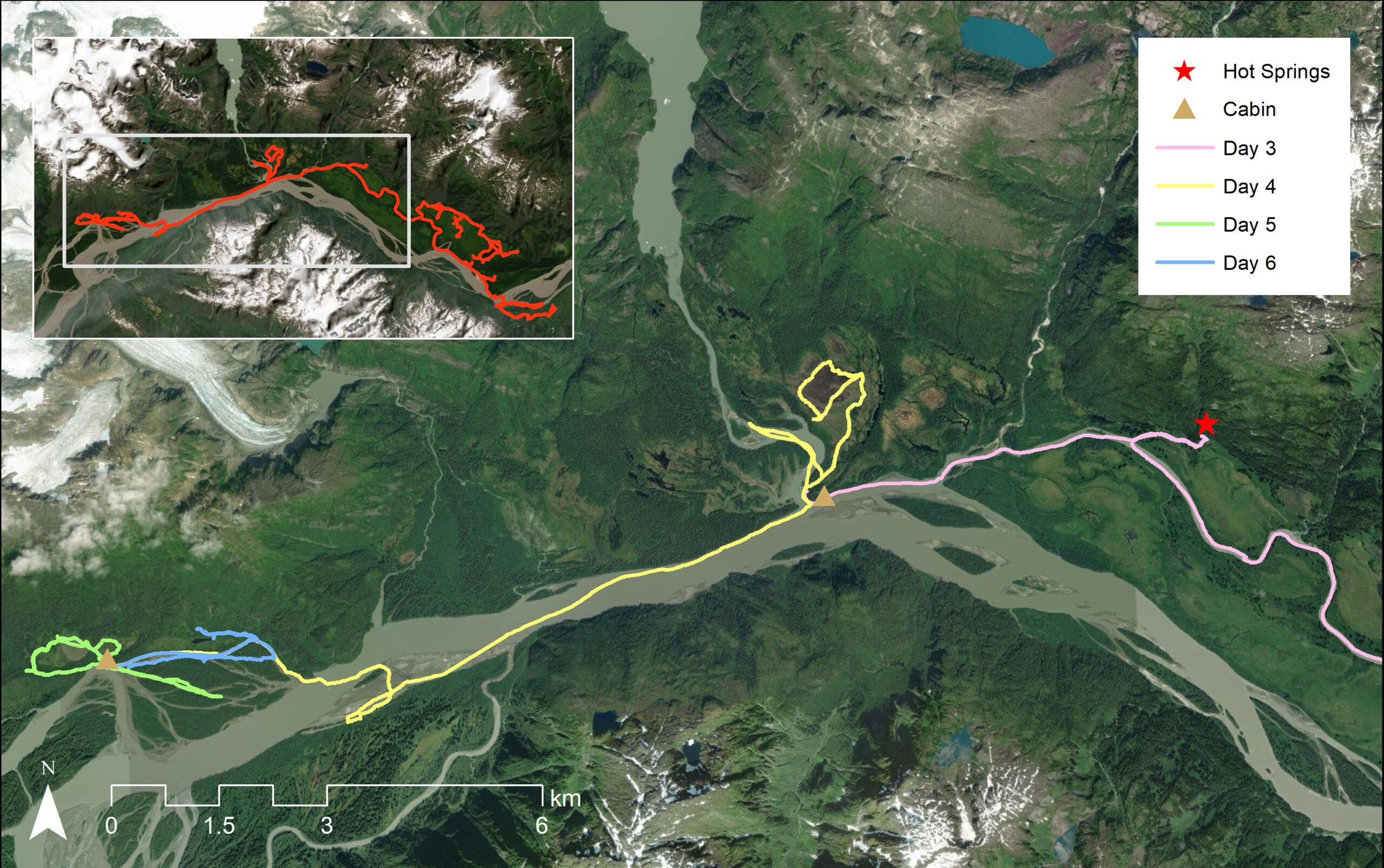
Map of tracks and bird locations of the last three days of birding along the Stikine River. Click to enlarge.
https://ebird.org/checklist/S71243735
Day 6: In the morning we found two Northern Rough-winged Swallows investigating Belted Kingfisher burrows in the large cut bank eroding to front lawn of Twin Lakes Cabin (just below the outhouse). The birds spent most of the day deciding between the two burrows, and later in the day were seen brining nesting material into the left-most hole. To our dismay we did not detect any Black-headed Grosbeaks around the cabin which had been the go-to locality from previous trip reports. We paddled back behind the cabin, exploring the lakes, and Nick did some fly-fishing.
https://ebird.org/checklist/S71243733
Day 7: We paddled upstream in a few of the surrounding sloughs in the morning before returning to Twin Lakes Cabin to be picked up at noon. The Northern Rough-winged Swallows were still present when we left, actively picking ash from our fire ring for their newly selected nesting spot.
https://ebird.org/checklist/S71243730
Article by Callie Gesmundo, Nick Hajdukovich and Zak Pohlen