

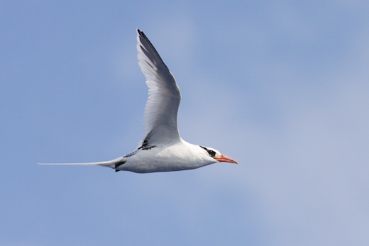
White-tailed Tropicbird (adult) - Virginia offshore waters - 7 July 2011 - photo by Tom Johnson.
Those of you actively watching the eBird rarities photo feed may have already seen some of the birds photographed by Tom Johnson, who is aboard the NOAA vessel Gordon Gunter. Given the relatively scarce coverage of this region, we thought eBirders would enjoy learning more about this research. The following article provides some details on this journey from one of North America’s most careful and thoughtful eBirders, Tom Johnson.
As a seabird enthusiast, I was fortunate to join a team of scientists on a marine mammal, seabird, and oceanographic survey for NOAA this summer in the North Atlantic Ocean off the southeastern US. The survey is six weeks long and began in mid-June in Pascagoula, Mississippi. Along with the crew, 14 mammal observers and acousticians, I boarded the 224-foot NOAA Ship Gordon Gunter and headed south through the Gulf of Mexico, cruising past the Dry Tortugas and through the Straits of Florida before arriving at the south end of the study area, offshore of central Atlantic Florida. The first leg of the trip carried us northward, where we zigzagged outside the continental shelf edge before reaching Norfolk, Virginia, in early July. The second half of the survey will involve similar tracklines heading back south toward Florida, mostly on the inshore side of the lines surveyed on the first part of the cruise.
This cruise is part of a program designed to visually and acoustically survey for marine mammals along predetermined tracklines. The mammal visual observers scan the ocean with huge 25×150 “Bigeye” binoculars. Each binocular is mounted on a solid platform with a fluidly rotating head, and includes a reticle scale to make measuring distance to far-away sightings possible. This amazing piece of optical equipment makes it possible to survey a three mile-wide strip along our tracklines through the ocean. Four mammal observers are on the Bigeyes at all times, and there is a rotating schedule to allow observers to rest their eyes. The acoustics staff listens for and records marine mammal sounds 24-hour a day via a hydrophone array towed behind the ship.
In addition to being a great platform for mammal observation, the Gordon Gunter is an ideal ship for conducting bird surveys. My role as a seabird observer involves tracking bird sightings within 300 meters of the ship as we progress along the tracklines. At any given time the survey effort is only directed toward one side of the bow, so I’m really just looking at a 90 degree wedge of ocean with a 300 meter radius. Of course, birds can be anywhere, so I’m constantly looking further out toward the horizon and occasionally turning around and checking the high rigging on the ship (more on this later). Whenever I detect a bird within “the zone,” I key it into a data collection program on a laptop computer. Each bird sighting is characterized by its precise GPS location, the species, number of individuals, sex and age (if determinable), association with other birds, distance from ship, and behavior.
Ultimately, the data from my survey and others will be used by NOAA to quantify seabird abundance, distribution, and habitat use in U.S. North Atlantic waters (see: www.nefsc.noaa.gov/psb/AMAPPS/).
So, what have we learned? Without statistical analysis of the line transect data, and because bird survey coverage this far offshore in this region has been scarce, I’m hesitant to draw any firm conclusions (yet). With that caveat in mind, there are a few species that are showing surprising trends this summer off the southeastern United States.
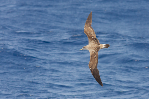
White-tailed Tropicbirds (below) were seen daily on the first leg of the cruise from Florida all the way north to Virginia, with up to 5 individuals recorded in a day.

Because most of these birds were in deep water (>1000 fathoms) far offshore, it is difficult to tell if it is an unusual summer for the species, with more tropicbirds dispersing north of their typical pelagic range, or if the high detection rate is simply due to the fact that we’re surveying waters that almost never get sampled by birders. During the late spring, Brian Patteson reported quite a few White-tailed Tropicbirds, with 8-9 seen over the course of 19 trips to Gulf Stream waters off Hatteras, NC. Brian’s reports (from an area that he surveys regularly), as well as a few reports of tropicbirds in the mid-Atlantic and Northeast by another NOAA cruise, suggest that this might be an unusual summer for tropicbirds in the region.
Of the White-tailed Tropicbirds that I’ve seen from the Gordon Gunter this spring, almost all were adults (2 immatures seen), and many flew in to the ship to investigate the high rigging, circling a few times before heading back off out of sight. Around half of the tropicbirds were first spotted swimming on the water, and one individual was even seen diving and catching flyingfish. Additionally, Red-billed Tropicbirds were encountered twice, both offshore from North Carolina.
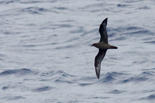
The other standout species on the first leg of this NOAA cruise has been Herald (Trindade) Petrel (the name Trindade Petrel is typically applied to the Atlantic form of Herald Petrel Pterodroma heraldica arminjoniana, which is sure to be split from the Pacific form in the near future). This dramatic Pterodroma has only been recognized as a regular visitor to North American Atlantic waters for about the last 20 years, but is still regarded as a very rare spring and summer visitor, primarily off North Carolina. We encountered Trindade Petrels regularly in very deep water off the Carolinas in late June and early July, with up to 11 in one day. These birds were almost all in water over 1000 fathoms in depth, often 150-200 miles offshore, water that is virtually never sampled by birders. The petrels were either seen alone or in association with feeding flocks of shearwaters, primarily Cory’s and Great Shearwaters. As expected, the majority were dark morph birds (pictured below), but 4 light morph Trindade Petrels were also encountered, including two striking individuals that were seen arcing together, turning and banking in tandem. Again, without a long-term data set, it is impossible to know for sure, but I am inclined to think that Trindade Petrels are regular, fairly common warm-season visitors to deep water off of the Carolinas.
Not all of the interesting birds that I saw on the first leg of the cruise were rare seabirds – in fact, some of the most puzzling observations I made involved species that are rather familiar on land. During several days of surveys north of the Bahamas in the third week of June, Yellow-crowned Night-Herons were a regular sight, 150-200 miles offshore. Unlike the high-flying behavior that I typically associate with onshore night-herons, these birds were practically skimming the waves! All were heading south or southeast singly or in groups of 2-4, for a total of 25 adult Yellow-crowns seen over the course of three days, distributed over a fairly broad swath of ocean. To me, this seems like a very unusual number for this species to be moving south in late June, but perhaps it is a regular movement that just hasn’t been detected before. Where were these birds going? Where were they coming from? Might they be birds that failed early at breeding attempts somewhere in the mid-Atlantic, or maybe even southern New England?
In addition to the survey transects for NOAA, I am also interested in recording the locations of particular sightings in my own personal records. This has brought up a fascinating conflict that I’ve only had occasional interaction with in the past: the charged subject of how to assign bird records to particular US states when the bird is well offshore of those states. There seems to be general agreement to accept the 200 nautical mile limit of the Exclusive Economic Zone (EEZ) of North America as the outer limit for bird records assigned to North American political units (states, provinces, territories, etc.). However, the ways that the state and provincial borders are determined are decidedly not standardized with respect to various regional bird records committees (BRCs). Generally, east coast BRCs choose to either extend straight-line boundaries eastward out from their state boundaries, or they like to use the “nearest point of land” method for establishing the possession of a pelagic record. Each of these processes poses its own combination of problems when applied across a wildly uneven coastline like the meandering coast of eastern North America. However, when different BRCs use different criteria to establish their pelagic zones (often maximizing their own pelagic area without regard to the decisions of neighboring states), chaos ensues, with numerous zones of overlap and/or gaps in coverage. eBird has addressed this by uniformly applying the “nearest point of land” convention to pelagic records.
Several amusing instances of pelagic zone overlap were brought to my attention during this cruise because of potentially important sightings in areas offshore from state borders. One of the more complicated cases involved a dark morph Herald (Trindade) Petrel that was seen and photographed due east of Georgia, but was actually closer to land in South Carolina due to the shape of the coastline. Neither Georgia nor South Carolina currently has any records for the species, and both states’ BRCs have expressed interest in reviewing the record.
Until someone convinces all of the coastal BRCs to come to an agreement regarding a standard for pelagic zones, we can always archive our sightings in eBird with the peace of mind that political assignment of offshore records can always be modified as long as the records are kept accurately in the first place. In reality, the political assignments of pelagic records are almost trivial, whereas exact location (GPS coordinates can be easily taken, ideally for every bird sighting), water depth, water temperature, and notes on any associations with other birds or marine life are much more important and informative with regard to the distribution of pelagic species, many of which are still poorly known at sea. The second leg of the NOAA cruise is already off to an exciting start, with calm seas, lots of marine mammals, and some excellent birds (South Polar Skua and White-tailed Tropicbird) off the Maryland/Virginia border. Hopefully I’ll be able to share a post-trip update of this exciting adventure with the eBird community.
Thanks, and good birding,
Tom Johnson, aboard NOAA Ship Gordon Gunter in the western Atlantic Ocean

Pomarine Jaeger is the most common jaeger offshore of the southeastern US in the summer. Overall, jaegers have been conspicuously scarce this summer.
Cory’s Shearwater is a common species in Gulf Stream waters in summer.
Red-billed Tropicbird, though rare, is a regular visitor to offshore waters from the Carolinas south.
All photos and text copyright Tom Johnson.