


One of the key aspects of the Atlas is attempting to survey the entire country, spreading out the community’s effort to ensure we gain as much of a complete picture as we can over the 5 years. As many of you will know, this will involve accessing harder to reach spots that will likely not receive a lot of data. The Department of Conservation (DOC) manages a third of New Zealand’s land area on behalf of all New Zealanders, and undertakes fantastic biodiversity monitoring throughout these areas. With this in mind, the Atlas team have been in discussions with the Tier 1 bird monitoring team to upload their bird count data to the Atlas dataset, to help with filling in some of these harder to reach areas.
Tier 1: Broad scale monitoring for national context:
Tier 1 monitoring delivers a groundbreaking systematic sampling programme for all public conservation land. The programme started in late 2011, and involves the regular assessment of a selection of native species and pests at locations 8 km apart and spaced evenly across the landscape – except where the site falls in a river or lake. Many of these sites are already being monitored for carbon by the Ministry for the Environment (MfE)/Manatū Mō Te Taiao as part of New Zealand’s Kyoto Protocol reporting. The biodiversity sampling programme builds on that activity and DOC works collectively with MfE to complete the sampling.
You can find out more about DOC Tier 1 monitoring here.
![]()
Value of Tier 1 data to the Atlas Dataset
We are over the moon to announce that the 2020/21 DOC Tier 1 bird counts have been uploaded into the Atlas eBird portal. This is the second season’s worth of valuable bird count data that has now been included in the Atlas dataset. An agreement exists now to upload the next three season’s worth of count data into the Atlas to help bolster the projects spatial and temporal coverage until the project finishes in June 2024.
This is a huge step forward for the Atlas project, especially as the upload has increased the Atlas community’s coverage both spatially and temporally, with the key summary stats shown below.
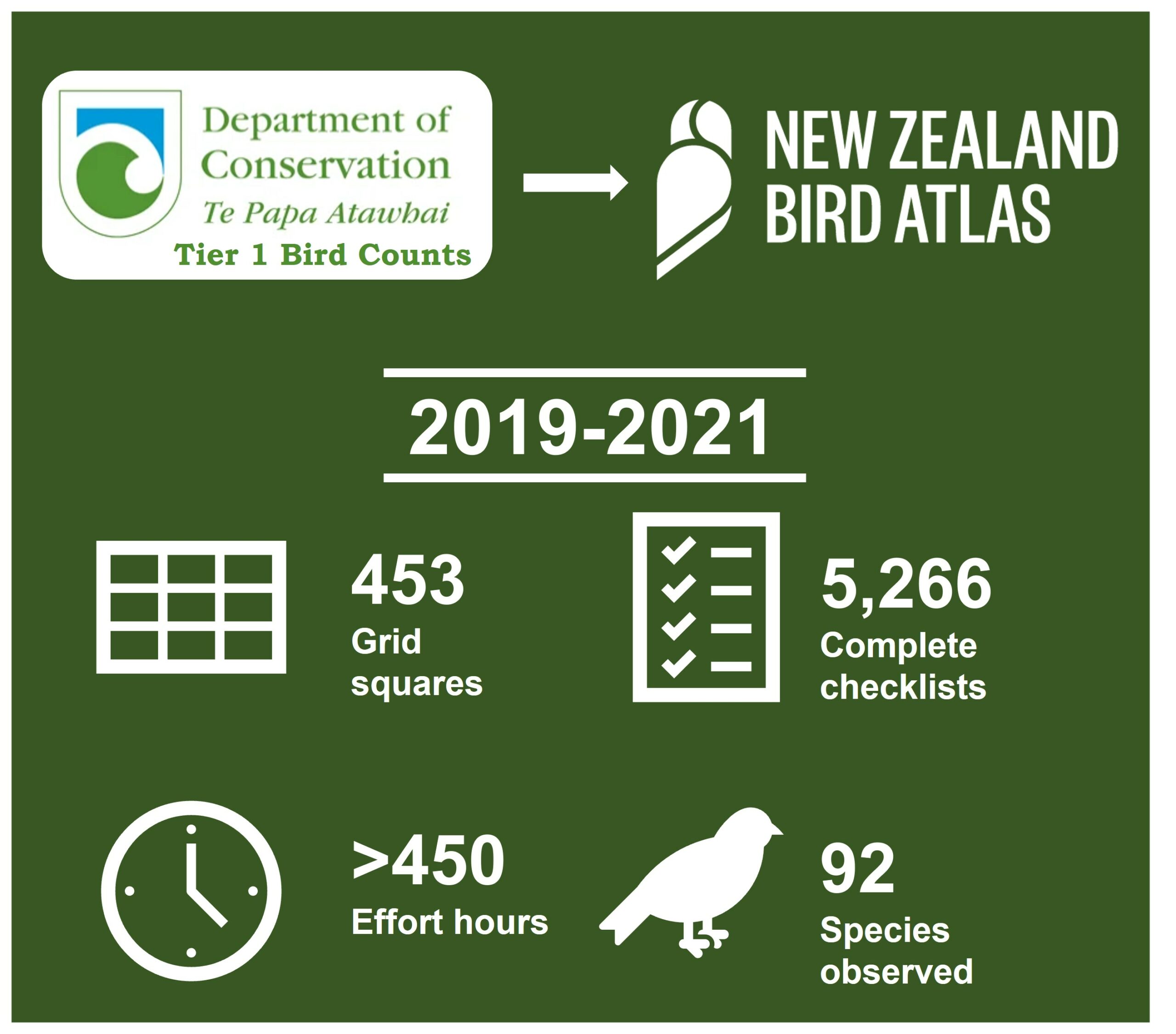
Figure 1 – Summary stats for Tier 1 bird count data in the Atlas portal
5,266 5-minute complete checklists have been uploaded to the DOC Tier 1 eBird profile, with 764 incidental checklists also uploaded, tallying up 6,030 checklists altogether that the DOC Tier 1 team have worked hard to compile, and now contributed to the Atlas dataset. The Tier 1 counts extend into some really remote areas of the country’s conservation areas, helping us to gather data in some incredibly tough to reach spots. With that in mind, roughly 100 grid squares will have nothing but, or mostly DOC Tier 1 data in them (such as CY27 on the West Coast). The Tier 1 counts extend over 453 grid squares, and have helped increase our coverage as shown below in Figures 2 and 3:

Figure 2 – Increases for seasonal effort after Tier 1 Data upload
The Atlas team would like to say a huge thank you to Tier 1 data management team for their hard work to come to an agreement with the Atlas team for the upload of the DOC Tier 1 bird count data. We’d also like to send a thank you to all of the Tier 1 field staff who have undertaken counts and gathered such vital data, and to those undertaking counts this season. Of course we will be working to encourage all staff to be uploading counts outside of the count period, such as walking to count stations, or when sat at a campsite or hut, to help increase coverage even more and continue to gather valuable data for the Atlas dataset to help us reach our target of full coverage across time and space.

Figure 3 – Map highlighting the coverage purely by DOC Tier 1 Count locations
Other organisations/data
If you work for, or know of other organisations, who undertake bird counts/surveys and have valuable bird observation data that could contribute and support the Atlas dataset, please do get in touch. We hope that this partnership with the DOC Tier 1 team can reveal how valuable collaboration is, but also how vital it is in the face of climate change, biodiversity loss and shifting baseline syndrome. We desperately need long term multi-generational datasets to better inform conservation research, management and policy across a wide range of local to international scales to better protect and help biodiversity recover. We are wholly interconnected and dependent on biodiverse ecosystems, and the only way we can help those to recover and flourish is through understanding the current state of species to then work towards better management.