


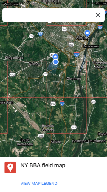
Screenshot from Google Maps (on iOS) showing your location as a blue circle. Priority blocks are outlined with thin red lines. You can use this map to navigate between checklists.
I just learned about another way to navigate to and within priority blocks using Google Maps. We still strongly recommend learning how to see your location in relation to block boundaries while conducting a checklist, but when you don’t have a checklist going, you can try the method below. Previously detailed options are located on the blocks page.
First Take These Steps On Your Computer
- Download the priority block boundary kml file to your desktop.
- Open Google Maps on your computer and sign in to your account (or create a google account if you don’t have one).
- Create a new map: In the search bar, click on the three horizonal bars on the left. Scroll down and select “Your Places.” Then go to “Maps” the right-most choice. At the bottom of the window, it says “create map.” Click on that.
- The new map prompts you to import a file (linked under the automatically created “untitled layer”). Import the block boundary kml file that you saved to your desktop in step 1.
- The boundaries will be added to the map. Save the map.
Now Follow These Steps On Your Phone
- Now open the Google Map app on your phone and make sure you are logged in to your account.
- On the bottom of the app screen you will see a “saved” option. Click on that. On the top of the app, scroll to the right until you come to “Maps” (on iOS I have “Lists,” “Labeled,” “Reservations,” “Following,” and then “Maps”). Select your saved map. Give it a few seconds to load the map.
- Now you can drive around and see the block boundaries without first having to create an eBird checklist.
Notes
- This is basically the same as using Google Earth but more people are comfortable with Google Maps.
- Also, you can’t navigate to a particular point AND see your saved map at the same time (or at least I haven’t figured this out yet). But you can drive around while seeing the roads AND whether you are in a priority block or not. One way around the inability to navigate to a point and have the block map open is to use two phones (e.g., use your birding partner’s phone to navigate and yours to see block boundaries).
- If the boundaries disappear, zoom in or out and they should show up again.
Let me know in the comments feature below if this works for you!
-Julie