


Pennsylvania is divided into 4,938 blocks, each about 3×3 miles. A major goal of the Atlas is to identify which species are breeding in each of these blocks. Each block is given the name of the U.S. Geological Survey quadrangle that it is located in, followed by a 2-letter code denoting the position of the block within the quad: northwest (NW), northeast (NE), center-west (CW), center-east (CE), southwest (SW), or southeast (SE). All southeast (SE) blocks are ‘Priority’ blocks for the Winter Atlas only (beginning December 2024). We aim to cover all 4,938 blocks for the Breeding Atlas.
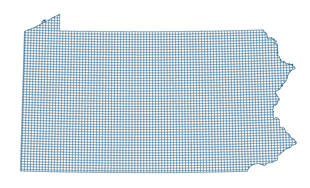
Pennsylvania Atlas Blocks
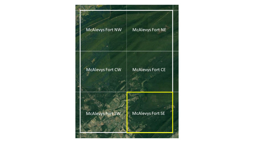
Six blocks forming a quadrant. All Southeast (bottom right) blocks are priority blocks for the Winter Atlas.
BLOCK MAPS
It’s important that all observations on each Atlas checklist occur within a single block. To help you know which block you are in while you are birding we offer maps in a couple formats along with tips for using other map types. Please use the map format that works best for you!
- eBird Mobile App – Using the Pennsylvania Bird Atlas portal in the eBird app allows you to see the block you are birding in, your location in the block, and block boundaries. If you experience any difficulties with this or other features while using the eBird app, the most effective solution is to delete and reinstall the app.
- PDF Maps – Static PDF maps can be downloaded from the Atlas Map Tool. We provide two maps for each block: one with roads and one with satellite imagery. Once you download the maps of interest to you, you can print them or store them on your mobile device for reference in the field. These PDF maps are also georeferenced meaning that they can be loaded into mobile GPS applications such as Avenza, allowing you to see your location plotted directly on the block map, even when you do not have a cell signal or internet access.
- Digital Maps – Block boundaries in digital format can be Download kmz files of block boundaries to load into Google Earth (a free program) or your favorite GPS app. A file for the entire state can be downloaded here. Files for each region individually can be downloaded here.
- Topographic Quadrangle Maps – See this guide if you need help sourcing a topo map.
- County Block Maps – Maps showing the blocks in each of Pennsylvania’s 67 counties can be found here.
SIGN UP FOR A BLOCK
If you are excited about atlasing a particular area, you can sign up to be the Principal Atlaser for that block. By signing up for a block, you are agreeing to:
- Spend around 20 hours surveying the block to confirm breeding birds, mostly during spring and summer.
- Spend around 2 hours surveying at night.
- Regularly submit your data through the Pennsylvania Bird Atlas portal in eBird.
- Provide additional documentation for rare or priority species.
- Monitor block progress and inform your County Coordinator when you believe the completion targets have been met.
It is not required to sign up for a block to participate in the Atlas, and you can submit observations from anywhere regardless of whether there is a Principal Atlaser or not. We encourage experienced birders to sign up for one or more blocks (up to 5 in one region, and 10 total across the state, at a time), as long as they intend to begin birding those blocks in that year. If you are a beginner birder, consider joining a more experienced partner or group in the first year to help you gain experience before signing up for a block. To sign up as Principal Atlaser for a block, use the Atlas Map Tool to find an available block and submit a request form.
HOW TO COMPLETE A BLOCK
To uniformly cover the state, we must put enough effort into surveying each block that we are reasonably certain we have observed most of the species breeding there, and then move on to other blocks. Once a block is designated complete, birders are encouraged to move on to incomplete blocks.
Breeding Atlas Block Completion Targets
For a block to be considered complete, we are looking for the following targets to have been met or exceeded. All 5 coverage targets need to be assessed before a block will be designated complete. A block can be completed in a single year or may take multiple years to complete.
- 70+ species* with breeding codes
- At least 25% Confirmed breeders
- No more than 25% Possible breeders
- Remaining species Probable breeders
- Minimum of 20 hours of Atlasing effort between April and August
- Minimum of 3 visits spread out across the breeding season (e.g., April, June, July)
- Include checklists in all accessible habitat types (e.g., forest, grassland, agricultural fields, forested wetlands, marshes, urban habitats)
- Minimum of 2 hours of nocturnal atlasing (preferably over 2 visits)
*This number will vary significantly across blocks and may be as high as 95+ species in some blocks or fewer in smaller border blocks. The species lists in the Block Tool provide the reported species for each block during the previous Atlases, and are helpful for determining which, and approximately how many, species to expect for a given block in the PBA3.
A running total of the species, breeding codes, and effort reported for each block during the PBA3 can be found at https://ebird.org/atlaspa/effortmap. These metrics will help you assess how well a block has been covered. Special effort should be made to Confirm rare, locally unexpected, and priority species.
We want to encourage every birder to contribute at whatever level you are comfortable with. A block’s Principal Atlaser will assess block coverage with assistance from the County Coordinator. If you are primarily birding in your yard or neighborhood, you don’t need to worry about block coverage goals, and your contributions may run well over 20 hours of birding without a block being considered ‘Complete.’