


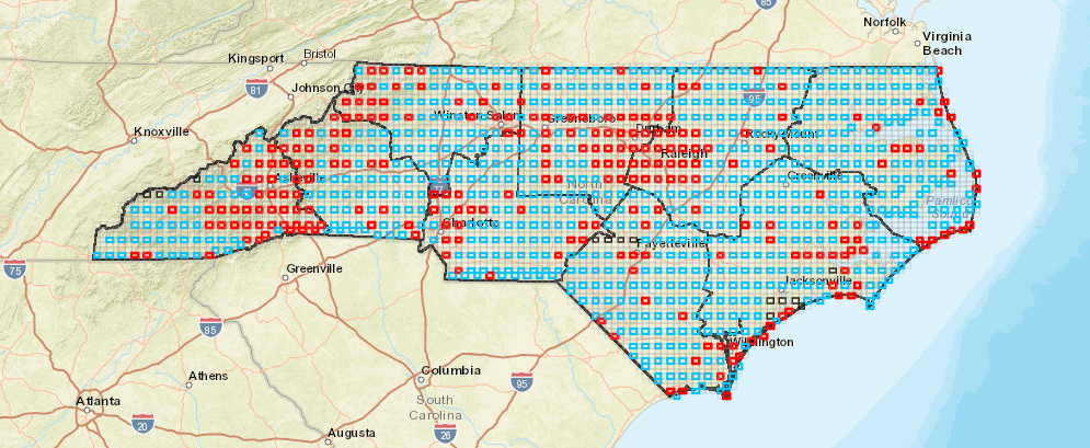
When looking at the NCBA Block Map, it is quite striking to see the difference between priority blocks that appear as “blue” and those that appear as “red.” What do these two colors mean? Simply put, blue blocks are priority blocks that have not been adopted and red blocks are priority blocks that have been adopted. Unfortunately, the blue blocks outnumber the red blocks almost 4 to 1. Fortunately, there is still time to change those blues to reds!
Before we jump into adopting a priority block, aka signing up as the primary Atlaser, let’s revisit the block system in general and why it is important for a Bird Atlas.
To make surveying the entire state of North Carolina more manageable and representative, sampling units called blocks have been established using a grid system based on 7.5-minute (1:24,000) topographic quadrangle maps (quads) prepared by the U.S. Geological Survey. Each of the topo quads that covers the state is further divided into 6 atlas blocks, each roughly 3 x 3 miles and encompassing about 9 square miles (~23 square km). This creates a system of approximately 5,600 blocks statewide. Of these, 937 were selected as priority blocks to ensure even coverage of the state by volunteer effort. While the importance of completing a priority block is emphasized, there is no restriction from atlasing in other blocks. In fact, surveys in non-priority blocks are welcomed, but not at the expense of priority blocks.
To help ensure all priority blocks receive effort, and ultimately marked complete, we encourage block adoption, whereby someone can sign up to be the Primary Atlaser. By signing up to be the Primary Atlaser for a priority block, you are agreeing to make sure that block meets all protocols to be marked as complete. Serving as the Primary Atlaser does not prevent someone else from reporting birds in that block. In fact, many block adopters encourage atlasing within their adopted block.
We encourage enthusiastic, experienced birders to sign up for multiple blocks (particularly blocks that are seldom visited) in the same year. If you are a beginning birder and not yet comfortable with your ability to identify birds, consider joining with a more experienced group or partner in your first year to help you gain experience. Of course, your Regional Coordinators are a great resource!
This article is featured in the March issue of the Quackalacky (the NC Bird Atlas Newsletter)!
Subscribe Here!
Signing up is easy!
Click on the Blocks (map and sign- up) link found on the NCBA home page. Use the interactive map to see which blocks in your region are targeted for priority surveying. All unclaimed priority blocks are identified by BOLD blue lines. A red border indicates the priority block has already been adopted.
- Click on a priority block you wish to adopt – make a note of the block name.
- Utilize the additional maps (Topo, Streets, Satellite) provided to identify block
boundaries while in the field with no cell service, or try using the free Avenza app. Note: block boundaries should now be visible within the eBird mobile app, too, but without satellite imagery when in remote areas. - Click “Sign-up” under status line to adopt the block. Please note that if there is not a sign-up link then the block has been taken or it is not a priority block.
- Complete the Google form by selecting the desired block name from the drop-down list.
- A confirmation email will be sent to you upon successfully adopting the block.
– Lee Sherrill is the Mountain Region Coordinator for the NCBA and a Science Support Specialist for WRC