Welcome to the Maryland & DC Breeding Bird Atlas!
The Atlas (MD-DC BBA3) is a five-year community-science project documenting where birds breed in Maryland and DC. This project began in 2020 and will wrap up at the end of 2024. Atlases were previously conducted here in the 1980s and the 2000s, which provides us with a powerful comparison of bird distribution changes in our region.
Sign up for eBird
To contribute to the Atlas dataset, first you’ll need an eBird account. Once you have created your account, take the free eBird Essentials course. This self-paced course will walk you step-by-step through eBird’s most popular features. You’ll learn how to keep checklists, explore data, and make your observations more valuable for science and conservation—all on your own time and completely free!
Use the Atlas Portal
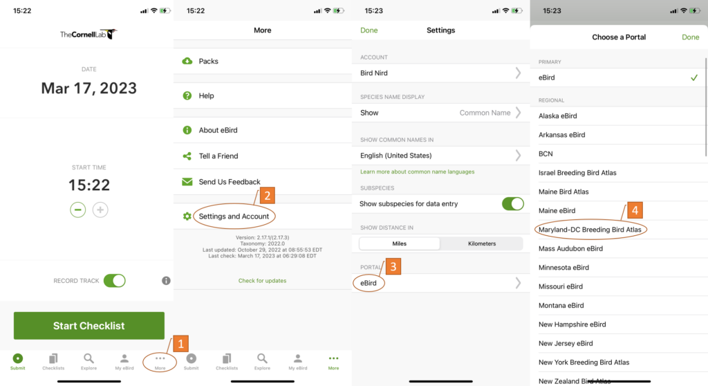
The Atlas portal is a label for eBird checklists. This label lets us know which eBirders were contributing observations to the Atlas dataset. If you are atlasing, make sure you are using the Atlas portal. You can change the portal in the mobile app’s settings, as shown below (examples are using iOS, but Android is similar).

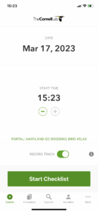
If you are using a portal, the portal name will always be displayed below the time, as shown in the screenshot below.

Where to Go
You can submit observations from anywhere in Maryland or DC, but the most valuable observations come from places that have had fewer people searching for breeding birds. To find these places, use the Atlas Effort Map on the eBird Explore page. The entire region has been overlaid with a grid of 3-mile x 3-mile blocks, and collectively observers go into each one of the 1,302 blocks to find as many breeding birds as they can. Eventually, the block has been sufficiently sampled and we consider it ‘complete’.
When is a block considered complete?
Our hard-working team of County Coordinators review each block annually to determine if it is complete. During their review, they assess whether the block has met these seven completion goals:
- 70 coded species
- 20 hours of daytime effort
- 1 hour of nocturnal effort
- Minimum of 25% Confirmed breeding codes
- Maximum of 25% Possible breeding codes
- All major habitat types sampled
- Effort occurred during the time of year
If a block has been marked complete, you can still atlas in that block—but your effort will have more impact elsewhere.
How to Atlas
You don’t need to be an expert in bird behavior to contribute valuable data to the Atlas. In its most fundamental form, atlasing requires just three simple steps:
- Identify a bird
- Categorize its behavior
- Report the observation
How much do you want to atlas?
Even though the fundamentals of atlasing are simple, there are a few basic protocols to follow to ensure our data are robust. Here is a list of things to do, depending on how much you want to participate.
Just a little
If you just want to submit the odd observation here and there,
- Record observations in the MD-DC Breeding Bird Atlas portal
- Keep short checklists (less than 3 miles)
- Stay within a single block (the app will notify you if you are crossing a block boundary)
Probably a medium amount
If intermediate participation is more your speed then, in addition to what is listed above,
- Use complete checklists
- Complete checklists are crucial for analysing our dataset
- Learn more about complete checklists
- Atlas in uncompleted blocks
- Adopt a block
- When you adopt a block, you agree to reach the block’s completion goals
- Find an unadopted block near you, then contact a County Coordinator to adopt it
As much as possible!
If you are all in on this project, then, in addition to what is listed above,
- Code breeding behavior whenever you see it
- Search for species that have not been found in the block
- Use these strategy maps to help identify species that may have been overlooked
- Travel to blocks that have low effort
- Go atlasing at night
- Several species are best detected after the sun goes down. Learn more about nocturnal atlasing.
Atlaser Resources
This pdf contains links to all of the main resources for atlasers. Download this so everything is just one click away!
Need Additional Help?
We’re always happy to help! If you have a question you can’t find the answer to online, contact the appropriate County Coordinator or the Atlas Coordinator.


